
|
SAN FRANCISCO REDEVELOPMENT
AGENCY MEMORANDUM TO: San Francisco Planning and Urban Research AssociationFROM: Stanley
Muraoka, Project Manager, Bayview Hunters Point and India BasinDATE: September 18, 2002RE: Pending Bayview Hunters Point Redevelopment Plan AmendmentsOpen Space Map Agency staff is currently working collaboratively with the Bayview
Hunters Point Project Area Committee on completing the adoption of three
Redevelopment Plan Amendments for the Hunters Point, India Basin Industrial
Park, and Bayview Industrial Triangle Redevelopment Project Areas. Following is information based on (1) a
workshop presentation to the Redevelopment Agency Commission on April 23, 2002
to update the Commission on the ongoing redevelopment planning efforts in the
Bayview Hunters Point Redevelopment Survey Area and (2) ongoing work of Agency
staff and the Project Area Committee on clarifying the community vision for
seven community-identified economic development activity nodes. Background The Board of Supervisors of
the City and County of San Francisco designated "South Bayshore"
(a.k.a. Bayview Hunters Point) as a Redevelopment Survey Area on January 3,
1995. Subsequently, on December
12, 1996, the Planning Commission adopted an Amended Preliminary Plan for the
Hunters Point Redevelopment Project to include the Survey Area. The December 1996 Amended Preliminary
Plan set the following proposed Bayview Hunters Point (“BVHP”)
Project Area boundaries: Cesar
Chavez Street on the north, U.S. Highway 101 on the west, the shoreline of San
Francisco Bay on the west, and the San Francisco County boundary on the south,
except for land in the Bayview Industrial Triangle, India Basin Industrial
Park, and the Hunters Point Naval Shipyard (see Redevelopment Survey Area Map). After the Agency received the
Amended Preliminary Plan from the Planning Department, Agency staff worked
closely with a number of persons in the BVHP community, to hold an election in
January 1997 to form a Project Area Committee (“PAC”) that would work
with the Agency on redevelopment planning for BVHP. Under the California Community Redevelopment Law, a PAC must
be formed if a Redevelopment Plan or Redevelopment Plan Amendment will provide
the Agency with the power of eminent domain over property occupied by low and
moderate income persons. Moreover,
the Agency and the community wanted to form a PAC that would work with the
Agency in planning the redevelopment of the area. On January 28, 1997, the Board of Supervisors confirmed the
election of twenty-one members of the PAC. The PAC also includes members representing the existing
Hunters Point Redevelopment Project Area. Redevelopment Plan
Amendments After the community election in January
1997, the PAC worked on a Community Revitalization Concept Plan with Agency staff
and a number of consultants. After
conducting many community workshops, a Revitalization Concept Plan was drafted
and approved by the PAC in November 2000.
Subsequently, the PAC produced an Executive Summary of the Concept Plan
in March 2001. The Concept Plan serves as the community’s vision statement that
guides the redevelopment planning process, and contains the community's goals and objectives for
revitalization of the BVHP area. Since completion of the Concept Plan, the PAC and Agency staff have been
working on redevelopment planning activities that would lead to the
implementation of the goals and objectives of the Concept Plan, including
amendments of the Redevelopment Plans for the three existing Redevelopment
Projects in BVHP: Hunters Point, India Basin Industrial Park, and Bayview
Industrial Triangle. Agency staff and the PAC will recommend that blighted portions of the
BVHP Redevelopment Survey Area be added to the Hunters Point Redevelopment
Project Area. To determine the
appropriate areas to be included in the Redevelopment Project, the Agency has
contracted with a plan adoption consultant team, led by Seifel Consulting,
Inc. The Seifel Consulting team
has completed a preliminary assessment of physical blight conditions within the
Survey Area and is set to complete a final blight analysis, including
assessment of both physical and economic blighting factors, in the next several
months. The outcome of this
analysis will be a recommended boundary for the amended Hunters Point Redevelopment
Project that will include areas of significant blight. Seifel Consulting will also prepare the
Preliminary Report on the proposed Redevelopment Plan Amendments including all
fiscal analyses and reasons why redevelopment is needed, and the Final Report
to the Board of Supervisors on the proposed amendments. Concurrent to the amendment of the Hunters Point Redevelopment Project,
Agency staff will recommend that land use districts in the India Basin and
Bayview Industrial Triangle Redevelopment Project Areas be amended to be
consistent with proposed land use and zoning changes in the adjoining Survey
Area. In addition, tax increment
financing will be instituted for the Bayview Industrial Triangle Redevelopment
Project, since no public funding mechanism currently exists to implement this
Redevelopment Plan. To satisfy California Environmental Quality Act environmental review
requirements, the Agency entered in to a contract with EIP Associates for
completion of an Environmental Impact Report (“EIR”) of the
proposed Redevelopment Plan Amendments.
The EIR will assess environmental
effects, such as increased local traffic and noise levels, alteration of public
views and building density, and increased demand for public services, and then
recommend measures to preclude any adverse effects or mitigate such effects to
less than significant levels. The three proposed
Redevelopment Plan Amendments will be supported by amendments of the South
Bayshore Area Plan of the City’s General Plan and other City General Plan
elements, amendments of the City Planning Code and Zoning Maps, a set of Design
Guidelines, the Preliminary Report, and the Final Report to the Board of
Supervisors. Each of these
documents will be reviewed and considered by the PAC, Agency Commission, and
the Board. The target date for
adoption of the Redevelopment Plan Amendments is March 2003. Regarding amendments of the
City Planning Code, the Board of Supervisors, in anticipation of the
Redevelopment Plan Amendments, adopted two resolutions, one that set up interim
NC-3 zoning controls over industrially zoned property directly adjacent to
Third Street in the BVHP Redevelopment Survey Area. The companion resolution urged the Redevelopment Agency to
amend the Redevelopment Plans for India Basin and Bayview Industrial Triangle
to establish land use a development controls consistent with a neighborhood
commercial district under the Planning Code. Bayview Hunters Point Project Area Committee
Throughout this redevelopment
planning process, Agency staff has worked closely and collaboratively with the
BVHP PAC. The Agency is committed
to continuing its partnership with the BVHP. It is significant to note that through the formal election
process, the PAC is the legally mandated voice of the community in recommending
the Redevelopment Plan Amendments to the Agency Commission and the Board of
Supervisors. Upon adoption of the
Redevelopment Plan Amendments by the Board, the PAC will assume the role of overseeing
the implementation of the Redevelopment Plans. Major Community Redevelopment Programs
Agency staff and the PAC will
recommend that the Redevelopment Plan Amendments establish three major
community redevelopment programs:
a Housing Program, an Economic Development Program, and a Community
Enhancements Program. Housing Program
The Housing Program will set
forth the Agency process for creating new affordable housing units in
BVHP. Staff and the PAC will
recommend that the Agency adopt a detailed implementation program, the Framework
Housing Program, which will be
continually consistent with the Citywide Comprehensive Affordable Housing Plan
and will detail Agency and City action in BVHP. Of significance, Agency staff and the PAC will recommend the
maintenance of the existing mix of ownership and rental housing. The Affordable Housing Program will
encompass a range of housing types, both rental and ownership, and including
multi-bedroom family housing and one bedroom dwellings. Moreover, Agency staff and the PAC will
recommend that the affordability target be set at the Bayview Area Median
Income (“AMI”), which is lower than the Citywide AMI. In addition, the PAC and
Agency staff will propose a Model Block Single Family Rehabilitation
Program that will address repair
and improvement of single family homes on a block-by-block basis in the
community. To guide the design and
appearance of the new housing construction particularly in mixed use
transit-oriented development along Third Street, the PAC and Agency staff will
recommend that the PAC, the Agency and the Planning Department establish a set
of Design Guidelines. Economic Development Program
The
intent of the Economic Development Program is to facilitate new development
that would be expected to directly and indirectly alleviate blight, and thereby
stimulate private sector investment and development in the area, and job and
entrepreneurial opportunities for local residents. The PAC and Agency
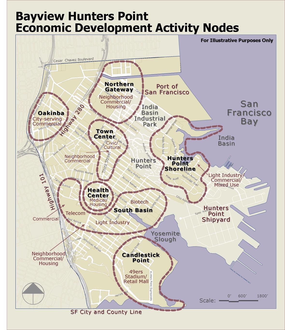
staff will recommend that the Economic Development Program focus public
investment in community revitalization within seven, community-identified
activity nodes, and that the Commission
would be authorized to adopt specific Development Programs for all or parts of each activity node, to guide
the economic development that will occur within the specific Development
Program area. Key to
the success of economic revitalization in BVHP is the Third Street light rail
project, which will create numerous opportunities for mixed use and other
appropriate transit-oriented development.
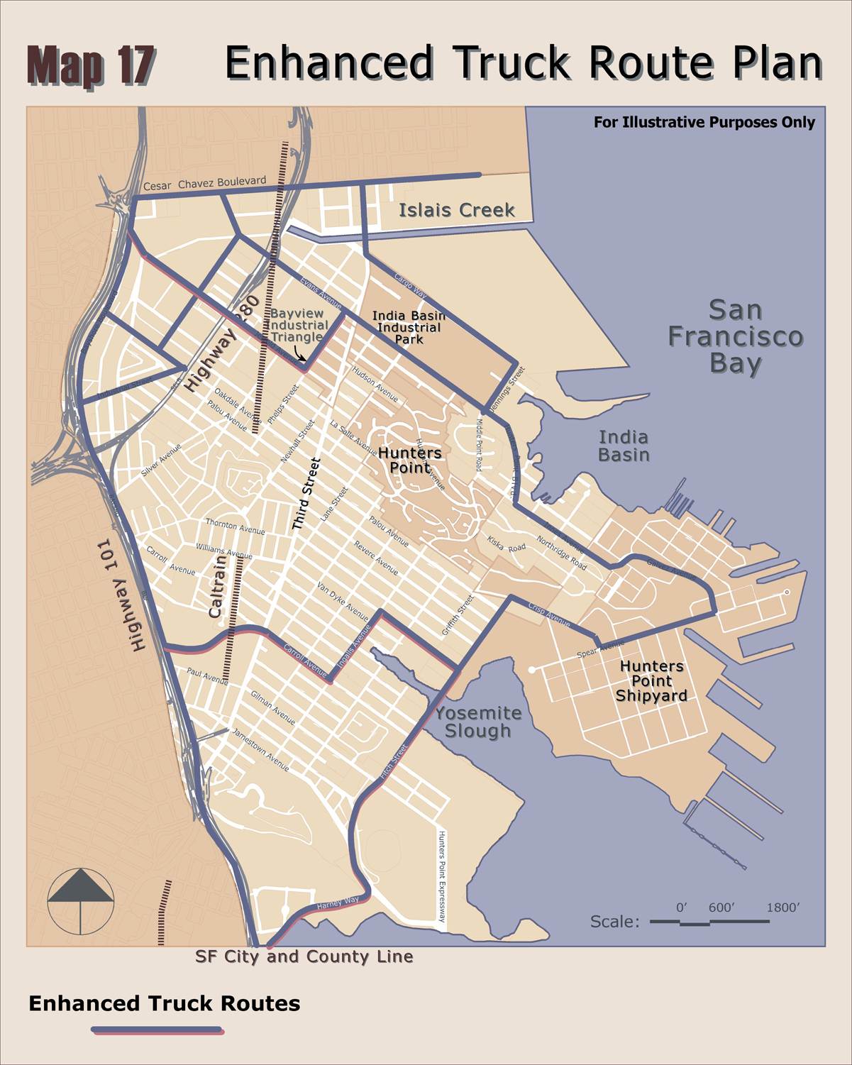
Another key is the enhancement of the northern route onto the Shipyard,
along Evans-Hunters Point Boulevard-Innes Avenue, and establishment of a
southern route onto the Shipyard, along an extension of Carroll Avenue from
Bayshore Boulevard to Third Street, up Carroll Avenue to Fitch Street, along
Fitch Street across a bridge over Yosemite Slough, connecting with Crisp
Avenue. Of particular note, Agency
staff estimates that the development of locally owned small businesses within
the seven economic development activity nodes would enable the community to
take direct action to stop the market leakage, currently estimated at well over
$100 million annually. The
fostering of local ownership and operation of new business throughout the Third
Street corridor and elsewhere in the community, and the associated significant
increase in employment of community residents and the concurrent increase in
affordable housing units are crucial to increasing the attractiveness of the
area for existing residents, to increase the earning power of existing
residents and businesses, and to preclude to the extent possible, the flight of
existing residents and existing businesses from the area, particularly as
outside businesses and new residents endeavor to move into the area to take
advantage of economic opportunities, both residential and commercial. The
seven economic development activity nodes include (1) the Northern Gateway
Activity Node, centered on Third Street between Islais Creek and Jerrold
Avenue; (2) the Town Center Activity Node, centered on Third Street between
Jerrold Avenue and Williams – Van Dyke Avenue; (3) the Oakinba Activity
Node, centered in the area bounded by Oakdale Avenue, Industrial Way and
Bayshore Boulevard; (4) the Southeast Health Center Activity Node, centered on
Third Street between Williams – Van Dyke Avenue and Carroll Avenue; (5)
the South Basin Activity Node, for the M-1 industrial area from Bayshore
Boulevard to South Basin on both sides of Yosemite Slough; (6) the Hunters
Point Shoreline Activity Node, centered on Hunters Point Boulevard –
Innes Avenue between Jennings
Street and Hunters Point Shipyard; and, (7) the Candlestick Point Activity
Node, for the Candlestick Point Special Use District (See Economic Development
Activity Nodes map). The
seven activity nodes represent an evolution from and a refinement of the four
Focus Area Plans that are described in detail in Chapter 5 of the PAC’s
Concept Plan: Town Center,
Northern Industrial District, Hunters Point Shoreline Area and South Basin
District. The Focus Area Plans
were the result of numerous community workshops and many hours of community
input starting in 1997 and culminating in the Final Draft of the Concept Plan
that was adopted by the PAC in November 2000. (1)
Agency
staff and the PAC will recommend that economic development in the Northern
Gateway Activity Node be focused on mixed-use, residential over commercial projects that will
increase business and employment activities in the northern Gateway area of
BVHP. New residential would be
encouraged in appropriate locations along Third Street to take advantage of the
transit-oriented development opportunities presented by the new Third Street
light rail line and to bolster existing residential uses in and adjacent to the
area. While the focus is on increasing
business opportunities, the community desires creation of enough retail and
service-oriented commercial businesses and housing units to form a true
neighborhood. The community also
wishes to promote locally-owned businesses and local entrepreneurship. Agency staff and the PAC propose that
land outside of the Evans Node in the Northern Industrial area to the east and
west retain permanent Industrial Protection Zone controls, with residential and
office uses prohibited, in order to both protect PDR industrial uses and
encourage new development to locate within the Gateway area. This
activity node incorporates the northern part of the Town Center Focus Area Plan
that, in the Concept Plan, extends from Evans Avenue to Williams Avenue. The Concept Plan vision for this
activity node area is characterized by ·
A protected historic
residential neighborhood, with a range of new infill housing and
transit-oriented mixed-use development focused around light rail stations on
the Third Street Corridor. ·
Local shopping and
entertainment venues on Third Street that incorporates and uplifts existing
businesses. ·
A major business and
employment development center in the northern portion of the Town Center,
adjacent to the Industrial Park and anchored by Bayview Plaza. ·
Transit hubs bringing
people to and from Bayview Hunters Point and providing connections to
employment, including Muni and CalTrain. This activity node also incorporates the north central
part of the Northern Industrial District Focus Area Plan that, in the Concept
Plan, extends from Bayshore Boulevard to Piers 80-92 in the Port of San
Francisco. The Concept Plan vision
for this activity node area is characterized by ·
Maintaining and
expanding industry within the area to increase the job base and support the
development of entrepreneurial opportunities. Economic
development with an ecological emphasis should be the focus; housing
development or live-work should not be allowed in industrial areas. ·
The promotion of
policies and land use decisions that provide job-training, employment and
business opportunities to local residents. ·
Economic development
that fosters clean industry and facilities to improve the quality of life for
area residents and workers.
Eco-industrial park development and operations principles are called
for. The
juxtaposition of the two Concept Plan visions along with the construction of
the Third Street Light Rail project creates a remarkable opportunity to build a
new San Francisco neighborhood, based on New Urbanism principles and signature
transit-oriented development projects, that would break through the barriers
posed by incompatible industrial and residential uses, foster improvements to
the environment and quality of life for residents and workers, and allow Third
Street to fulfill its potential as a neighborhood-serving street. (2) Development
in the Town Center Activity Node is to be anchored by the Town Center block, bounded by
Third, Newcomb, Lane, and Oakdale.
This block is entirely City-owned and includes the Bayview Opera House
owned by the Art Commission, Joseph Lee Gym owned by the RecPark Department,
and the former Burnett School owned by the Unified School District. Agency staff, along with staff of the
Mayor’s Office of Economic Development and other City departments, is
working on possible future development of the Town Center block. This block represents the single
largest opportunity in BVHP to provide new community space, and would allow for
the consolidation of community, educational and training services for the
entire community in a central location.
Efforts initiated by the Bayview Opera House Board to fully renovate the
Opera House building and add classroom and other community space in a new,
adjacent facility is a foundation for this City effort. For the blocks that neighbor the Town
Center block, there are numerous opportunities to rejuvenate this core
commercial area with restaurants, neighborhood stores, and other commercial
businesses, and to add new housing units as the opportunity arises, in mixed use
(residential-over-commercial) buildings adjacent to Third Street. The community also wishes to promote
locally-owned businesses and local entrepreneurship. Currently, the Agency is providing assistance to the
Providence Baptist Church, located next door to the Town Center block on Third
Street between Newcomb and McKinnon Avenues, on their senior housing project,
and working with the San Francisco Housing Development Corporation on a
mixed-use affordable housing project at 4800 Third Street (at Oakdale Avenue). This activity node incorporates the central and southern
portion of the Town Center Focus Area Plan that, in the Concept Plan, extends
from Evans Avenue to Williams Avenue.
The Concept Plan vision for this activity node area is characterized by ·
A protected historic
residential neighborhood, with a range of new infill housing and
transit-oriented mixed-use development focused around light rail stations on
the Third Street Corridor. ·
Local shopping and
entertainment venues on Third Street that incorporates and uplifts existing
businesses. ·
Projects and land
uses that establish the Town Center as a cultural arts destination, with an
emphasis on exceptional public art interwoven with infrastructure and
buildings. Community destinations and gathering places – including a
Farmer’s Market/Community Marketplace, plazas, and locations for
festivals, fairs and community events. ·
Transit hubs bringing
people to and from Bayview Hunters Point and providing connections to
employment, including Muni and CalTrain. ·
Civic, educational,
and community service facilities brought together to form a “mall”
on Third Street and along Oakdale. (3) The PAC seeks the creation of a
vibrant commercial center that is compatible with both nearby residential
neighborhoods and adjacent light industrial uses within the Oakinba Activity
Node. Given the adjacency of the U.S. Highway 101 and major
arterials linking City neighborhoods, the availability of relatively large land
parcels, and the visibility of the area from the major roadway leading from San
Francisco International Airport to downtown San Francisco, the Activity Node is
uniquely positioned to accommodate larger-scale, City-serving commercial
businesses. However, careful
siting and design is required to assure compatibility with surrounding
residential and industrial areas. This activity node incorporates the western part of the
Northern Industrial Area Focus Area Plan that, in the Concept Plan, extends
from Bayshore Boulevard to Piers 80-92 in the Port of San Francisco. The Concept Plan vision for this
activity node area is characterized by ·
Maintaining and
expanding industry within the area to increase the job base and support the
development of entrepreneurial opportunities. Economic
development with an ecological emphasis should be the focus; housing
development or live-work should not be allowed in industrial areas. ·
The promotion of
policies and land use decisions that provide job-training, employment and
business opportunities to local residents. ·
Economic development
that fosters clean industry and facilities to improve the quality of life for
area residents and workers.
Eco-industrial park development and operations principles are called
for. (4) The community seeks the creation
of a center for medical offices and clinics to serve the entire BVHP community
within the Southeast Health Center Activity Node. The
medical service center is proposed to be directly adjacent to the Third Street
light rail line. Agency staff and
the PAC will recommend that activity within this node build upon the proposed
expansion of the existing Southeast Health Center, which is owned by the
Department of Public Health, by adding private medical offices and support
services and businesses to support those services available through the Public
Health Department. The Health and
Environment Resource Center, using a grant from the Department of the
Environment, has initiated predevelopment planning for the Health Center
expansion. To take advantage of
the opportunities for combining residential and neighborhood retail with
medical services, particularly as it relates to providing a complete
neighborhood for community elderly persons, the community seeks to focus on
building new housing, both senior and multi-family, and encouraging new retail businesses
within this activity node in transit-oriented development projects adjacent to
Third Street. The community also wishes to promote locally-owned
businesses and local entrepreneurship. This activity node incorporates the central portion of
the South Basin District Focus Area Plan in both sides of Third Street. In the Concept Plan, this Focus Area
Plan extends from Bayshore Boulevard to Yosemite Slough and South Basin. The Concept Plan vision for this
activity node area is characterized by ·
An enlarged Southeast
Health Center with an Aging Campus, clustered senior services and new senior
residential facilities. ·
Transit hubs along
Third Street bringing people to the Southeast Health Center and Aging Campus
with larger-scale mixed-use commercial businesses located along the corridor. ·
Community
destinations and gathering places – including plazas along the Third
Street corridor, a renovated Bayview Park, community gardens and parks
extending through the Health Center and Senior Living areas, and a restored and
redeveloped Yosemite Slough on State Park land. ·
An office
“park” area, with medical and other types of office uses bounding
the Health Center and buffering adjacent residential from to industrial uses to
the southeast. ·
A focus on housing
for senior living around the Southeast Health Center including assisted-living
facilities. (5) The intent of the community for
the South Basin Activity Node,
i.e. the remainder of the South Basin area outside of the Southeast Health
Center Activity Node, is to encourage transit-oriented development adjacent to
Third Street to take advantage of the Third Street light rail line, and to
preserve land between Third Street and Bayshore Boulevard, and between Third
Street and Yosemite Slough as permanent Industrial Protection Zones, with
residential and office uses
prohibited. Along the edges of
this South Basin Activity Node, where industrial uses become intermixes with
residential uses, the community seeks to buffer homes from industry and to add
small-scale neighborhood commercial services as the opportunity arises. The community also wishes to promote
locally-owned businesses and local entrepreneurship. This
activity node incorporates that part of the South Basin District Focus Area
Plan on either side (both west and east) of the Southeast Health Center
Activity Node. In the Concept
Plan, this Focus Area Plan extends from Bayshore Boulevard to Yosemite Slough
and South Basin. The Concept Plan
envisions a number of development centers within this activity node, including a large-scale commercial area along Bayshore Boulevard
to the west, an eco-industrial park to the east, and a major waterfront park at
Yosemite Slough on the eastern shoreline.
The Concept Plan vision for this
activity node area is further characterized by ·
Transit hubs along
Third Street bringing people to the Southeast Health Center and Aging Campus
with larger-scale mixed-use commercial businesses located along the corridor. ·
Community
destinations and gathering places – including plazas along the Third
Street corridor, a renovated Bayview Park, community gardens and parks
extending through the Health Center and Senior Living areas, and a restored and
redeveloped Yosemite Slough on State Park land. ·
An office
“park” area, with medical and other types of office uses bounding
the Health Center and buffering adjacent residential from to industrial uses to
the southeast. ·
A formalized
eco-industrial park in the southeast portion of the district, with defined
truck routes linking the Shipyard and the freeway. ·
Protected historic
residential neighborhoods, with a range of new infill housing and
transit-oriented mixed-use development focused around light rail stations. ·
Renovation of the
Alice Griffith Housing Development, with massive improvements in street layout
and infill that reunites the enclave with the rest of the neighborhood. (6) The Hunters
Point Shoreline Activity Node, located along Hunters Point Boulevard and Innes Avenue
has two facets. First, there is a
residential facet, where the community and the Housing Authority are looking to
build new housing on available infill development sites west of Innes
Avenue. The Housing Authority
intends to again submit an application for Hope VI funds to renovate Hunters
View. Agency staff is working with
the Housing Authority to include Housing Authority projects in the proposed
Hunters Point Redevelopment Plan Amendment, including Hunters View and Alice
Griffith, for which the Housing Authority will also be seeking Hope VI funds. Second, for the land lying east of
Innes Avenue, the intent of the community is to create a mixed-use neighborhood
of small industrial businesses, mixed with neighborhood-serving retail and
commercial services and some residential units. This neighborhood would be water-oriented to take advantage
of the Hunters Point Shoreline Park that is currently being expanded by the
RecPark Department, other City departments and the Trust for Public Land. The Shoreline Park, upon completion,
will extend from Heron’s Head Park to Hunters Point Shipyard. The area would be a refuge for artists
who may choose to relocate to this area from the Hunters Point Shipyard. This activity node incorporates the Hunters Point
Shoreline Focus Area Plan in the Concept Plan. The Concept Plan vision for this activity node area is
characterized by · Water recreation along the India Basin Shoreline
and public access to the waterfront. · Rehabilitated public housing that ties in
physically and architecturally to other residential development in the
community. · New mixed-use residential developments that feature
ground floor neighborhood-serving businesses and housing above in appropriate
locations on the north side of Innes Avenue. · New mixed-use development centers with flexible
land uses on the PG&E and Ferrari sites that take advantage of these large
parcels of land. · Facilitate and complete the cleanup of hazardous
substances from identified contaminated sites, particularly the PG&E site
and the Ferrari parcel. (7) The Candlestick
Point Activity Node will accommodate the San Francisco 49ers stadium and mall. The project consists of a new football
stadium built on the existing parking lot and a new stadium parking lot on the
site of the existing stadium. In
addition, there is proposed a new 1.2 million square foot retail shopping mall
adjacent to and east of the new stadium.
At the point in time when the 49ers have a specific development proposal
for the stadium-mall, the Mayor’s Office of Economic Development and the
Agency would be involved in the project entitlement process. In
June 1997, San Francisco voters approved Propositions D and F, which defined
the new 49ers stadium and proposed mall.
Proposition D authorized public financing in the form of lease revenue
bonds for the Candlestick Point stadium and related infrastructure (including
but not limited to, parking, streets and highways, and water and sewer
systems), facilities, structures, equipment and furnishings. Proposition F approved the development
of the stadium and mall project, making the necessary General Plan, Planning
Code and Zoning Map amendments to amend the height limit to 200 feet for the
stadium and 60 feet for the mall, and establishing the Candlestick Point
Special Use District. As stated earlier, Agency
staff and the PAC propose that the PAC, the Agency and the Planning Department
establish a set of Design Guidelines for the construction of transit-oriented development
along Third Street as well as the construction of new building types throughout
the community. Community Enhancement Program
Agency staff will recommend
that a Community Enhancements Program be established to improve and enhance
community character through beautification of streets, establishment of a Façade
Improvement Program, the creation
of a Green Streets network,
the improvement of existing community and recreational facilities and open
spaces, and the construction of new urban plazas and miniparks. Of significance, staff
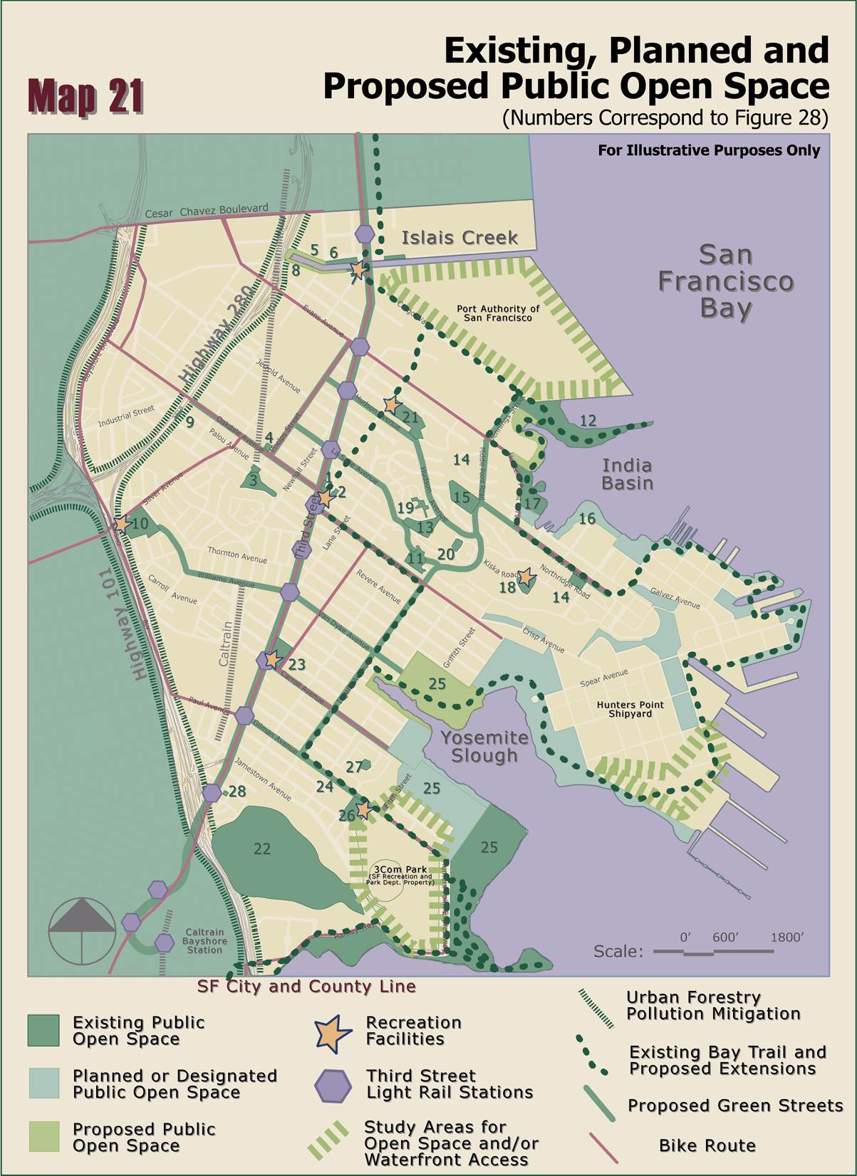
proposes the adoption of a Framework Open Space Program to guide the improvement, maintenance and programming
of Agency and City Recreation and Park Department open spaces in the area. Agency staff has initiated discussions
with the Recreation and Park Department on the conveyance of Agency-owned open
space parcels in the Hunters Point Redevelopment Project Area, from the Agency
to the Recreation and Park Department, in order to bring all the major improved
open spaces in BVHP under a single City jurisdiction, pursuant to the proposed
Framework Open Space Program. Agency staff also proposes
the adoption of Streetscape Plans for the three major roadways in the community, Third Street, the
northern route to the Shipyard, along Evans and Innes Avenues, and a new
southern route into the Shipyard. |